⚠️ Affiliate Disclosure: BuyCycleWorld.com is a participant in the Amazon Associates Programme, an affiliate advertising programme designed to provide a means for sites to earn advertising fees by advertising and linking to Amazon.co.uk. When you click our links and make a purchase, we may earn a small commission at no extra cost to you. This helps us keep the site running and the reviews coming. We only recommend products we genuinely believe in.

Getting lost on a cycling tour can be an adventure. Ending up on a dual carriageway with a loaded bike is not. The right navigation tools — whether apps, dedicated GPS devices or traditional paper maps — make the difference between a memorable route and a stressful detour. Here are the best cycling navigation resources for UK cyclists.
Top Picks
Komoot Premium Cycling Navigation App
Komoot has established itself as the go-to route planning and navigation app for cyclists across Europe. The surface type analysis helps you understand exactly what kind of terrain your route includes — crucial for deciding which tyre to fit before a tour. The offline map download means navigation continues regardless of mobile signal, which is essential on remote UK routes.

- Reliable Anti-Theft Warning: These 2pcs bike tracker stickers act as a strong anti-theft warning. They deter thieves by …
- Weather-Resistant: Made with weather-resistant materials, these stickers are designed to endure all weather conditions. …
- Easy To Apply And Remove: These tracker stickers are simple to apply and remove. The adhesive back ensures a secure fit,…
Wahoo ELEMNT Roam GPS Cycling Computer
For cyclists who prefer a dedicated device over a phone, the Wahoo ELEMNT Roam provides colour mapping, turn-by-turn navigation and seamless integration with Komoot, Strava and Ride With GPS. The battery life handles full touring days and the bright display remains visible in both direct sunlight and low light. A self-contained navigation solution that does not drain your phone battery.

- 【Smart MAP Navigation】You can set routes and send to BiNavi bike computer from the iGPSPORT APP. It also supports import…
- 【Yaw Planning】Once off course, the bike computer automatically plans a new route to right route.
- 【Saved Point Navigation】The cycle computer can plan routes to previously saved locations at any time.
OS Explorer Cycling Map Sheets
Ordnance Survey maps remain the definitive source for navigating the UK countryside. The 1:25,000 Explorer series shows every bridleway, footpath, track and lane in the country with unmatched accuracy. For touring cyclists using the NCN or planning multi-day off-road routes, a set of relevant OS sheets provides a reliable backup that works without battery or signal.

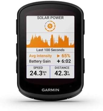
Garmin Edge 840 Solar GPS Cycling Computer
Garmin’s Edge 840 Solar extends battery life via solar charging — a significant advantage on multi-day tours where charging opportunities are limited. The colour touch screen displays Ordnance Survey and Garmin Cycle Maps, turn-by-turn navigation is smooth and accurate, and the Climber Pro feature provides gradient and summit information for hilly UK touring routes.
- The advanced GPS bicycle computer with touch screen and button control combines superior navigation, planning and monito…
- High-performance GPS bike computer with mapping and touch screen
- Multi-frequency reception of the global satellite system
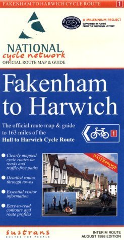
Sustrans National Cycling Network Route Maps
Sustrans publish detailed route maps for each of the major National Cycling Network routes in the UK. If you are planning a long-distance UK tour on routes like the Coast to Coast, Land End to John O Groats (C2C, LEJOG) or the Pennine Cycleway, the official Sustrans maps provide accurate and regularly updated information on surface types, services and points of interest.
Buying Guide
Download offline maps before leaving mobile signal. Even the best apps become useless without data connectivity in remote areas. Always carry offline maps for your entire planned route.
A dedicated GPS device is more reliable than a phone for navigation. Phones run out of battery, overheat in direct sunlight and are a theft target. A cycling GPS handles all these scenarios better.
Paper maps are a backup, not an alternative. Carry one or two relevant OS sheets for remote sections of your route. They work in all weathers, never run out of battery and cannot be hacked.
Plan beyond your planned route. Always download map data for adjacent areas in case you need to deviate due to weather, road closures or mechanical issues. A 20km detour off your planned route should not leave you lost.
Review your route before riding it. Checking the route at home on a large screen reveals potential issues — long sections without services, unexpectedly technical terrain or road junctions that require care — that are harder to spot on a small screen mid-ride.
🚴 Related Reading
Final Thoughts
Komoot paired with a Wahoo or Garmin GPS computer is the definitive navigation setup for UK cycle touring. Always back this up with relevant OS Explorer sheets for remote sections and the official Sustrans maps if you are following NCN routes.
Buying Guide
Cycling navigation tools — whether paper OS maps, dedicated GPS computers or smartphone apps — guide cyclists through the UK’s extensive network of lanes, bridleways, National Cycle Network routes and off-road trails. The best navigation solutions for UK cycling combine accurate, up-to-date mapping with cycling-specific routing that prioritises quiet lanes, off-road paths and legally accessible bridleways over main roads and footpaths.
| Factor | What to Look For |
|---|---|
| UK Coverage and Map Accuracy | Ordnance Survey mapping is the gold standard for UK cycling navigation, with 1:25,000 scale detail showing every bridleway, byway, footpath and right of way designation. Apps and devices using OS mapping (Komoot with OS layer, ViewRanger, OS Maps app) provide accurate off-road routing unavailable in OpenStreetMap-only platforms. For road cycling, HERE Maps and OpenCycleMap (used by Komoot) cover the UK road network comprehensively with less detail on off-road rights of way. |
| Routing Algorithm Quality | A cycling-specific routing algorithm that selects quiet lanes over main roads, optimises for gradient where preference is stated and correctly routes along National Cycle Network paths represents the key differentiator between general navigation apps and cycling-specific tools. Komoot’s UK routing is considered among the best for combining road and off-road navigation; RideWithGPS offers excellent manual route-building tools for cyclists who create routes rather than use auto-generated ones. |
| Offline Capability | UK cycling often ventures beyond reliable mobile data coverage — in the Highlands, Welsh uplands and remote Pennine routes, 4G data is intermittent or absent. Apps that download map tiles for offline use (Komoot, OS Maps, Maps.me) function without a data connection. GPS devices (Garmin, Wahoo) store maps internally and are the most reliable option in areas with no mobile coverage. Confirm the offline area size limitation of any app before relying on it for a remote UK touring route. |
| Integration with Training Platforms | Apps that integrate with Strava, Garmin Connect, TrainingPeaks or Wahoo allow routes to be planned on a computer and pushed to a GPS device or phone for navigation, with ride data automatically synced to training logs. This workflow is standard among UK club and sportive riders who plan routes in advance. RideWithGPS and Komoot both offer deep Garmin and Wahoo device integration; Strava Route Builder is popular for its simplicity despite less sophisticated routing. |
| Turn-by-Turn Navigation Quality | Clear, timely turn cues are essential on unfamiliar UK country lanes where junctions are often unsigned and appear suddenly. A device or app that announces turns 50 to 100 metres before the junction allows adequate preparation time at 30 kph. Voice prompts through connected headphones are useful for road rides; screen-only cues are adequate for slower off-road navigation. Map colouring that highlights the cycling route against surrounding roads is a simple but effective design feature. |